Showing posts with label Bealey Hut. Show all posts

Wednesday, 9 January 2019

Campsites around Arthurs Pass National Park

A variety of camp-sites in Arthur's Pass...

There are a number of camp sites within Arthur's Pass National Park, all of them are accessible from SH73 so you tend to share them with freedom campers and tourists in camper vans. There is one on the western side and six on the eastern side of the pass.

Kelly Creek Camp-site: West Coast

Kelly Creek camp-site is on the western side of the main divide about 2 kilometres past Otira settlement. It is a very basic camp-site located next to the car-park along Kelly's Creek. The Cockayne Nature Walk is co located at the car park, this is a nice 20-30 minute ramble through the local bush. This is also the start point for the track to Carroll Hut which sits on the ridges over looking Kelly's Creek. 

Kelly's Creek car-park and camp-site, Arthur's Pass National Park

  • Located 20 km west from Arthur's Pass DOC visitor centre on Highway 73.
  • FREE
  • NO Advance Bookings - first in, first served!
  • Camper vans permitted (no powered sites)
  • Facilities: Long drop toilet, water is from Kelly's Creek (treat before use)
  • No pets permitted under any circumstances.
  • Take your rubbish with you!
  • Note: Roadside shelter was removed in December 2007!


Map: Kellys Creek Car-park and Cockayne Nature Walk


There are a lot of car break-ins at this car park so hide any valuables out of sight if you leave your car here for any length of time.

Avalanche Creek, Camp-site and day shelter

The main camp-site and the one closest to Arthur's Pass township is the Avalanche Creek shelter and camp-site. There is space here for about 10 small tents as well as lots of space for camper vans to park. The shelter is large and can easily hold a sizeable number of people. 

Note: you may not sleep inside the shelter and this is regularly policed by the local DOC Rangers.

Avalanche Creek Shelter and camp-site, Arthur's Pass National Park

  • Located across road from the Arthur's Pass DOC visitor centre
  • NO Advance Bookings - first in, first served!
  • Camper vans permitted (no powered sites)
  • Cost $8 pp / night. Payable at site, or DOC Visitor Centre opposite.
  • Facilities: Water, toilets, day-use shelter with tables, rubbish disposal.
  • No pets permitted under any circumstances.
  • No open fires permitted!
  • Warning: Do not leave your tent unattended as the Kea will dismantle it for you!


Map: Avalanche Creek Campsite

The shelter is a substantial affair, you could easily get 40 people inside at one time as it has numerous tables and benches. Camping sites are on the lawn to the front, side and rear of the shelter. 


Avalanche Creek Shelter and camp-site, Arthur's Pass National Park

Plenty of space for camper vans at the Avalanche Creek Shelter, Arthur's Pass National Park


Avalanche Creek Shelter, Arthur's Pass National Park

Interior of the Avalanche Creek Shelter, Arthur's Pass National Park

Interior of the Avalanche Creek Shelter, Arthur's Pass National Park

Interior of the Avalanche Creek Shelter, Arthur's Pass National Park

 
Useful information board in the Avalanche Creek Shelter, Arthur's Pass National Park

 The Avalanche Peak Track starts close to this shelter, it is located right next to the DOC visitor center on the opposite side of SH73.

Greyney's Shelter

Greyney's Day Shelter is the start point for a number of tracks: the Old Coach Road, the Mingha-Deception Track and the route to Edwards Hut. This used to be a DOC camp-site but since recent road realignment camping is no longer permitted here.


The picnic area at Greyney's Shelter, Arthur's Pass National Park
Self contained camper vans CAN use this site, there are clearly marked spaces they are allowed to occupy.  The very busy SH73 is right next to the shelter site so it is a bit noisy. There is no water anywhere near here so you need to bring supplies with you.
  • Located 5 km east from Arthur's Pass DOC visitor center on State Highway 73.
  • FREE
  • Camper vans permitted (no powered sites)
  • Facilities: Day use shelter, long drop toilet
  • No pets permitted under any circumstances.
  • Take your rubbish with you!
  • Fires in shelter fireplace only!

Map: Greyney's picnic & shelter site


Greyneys Day Shelter, Arthur's Pass National Park


Interior of Greyneys Day Shelter, Arthur's Pass National Park

 Klondyke Corner shelter & camp-site

 The Klondyke Corner shelter and camp-site is located on the edge of the national park just off SH73. The shelter is available to all visitors and is open on three sides with a fourth wall which includes an open fireplace. The camp-site is very basic there is no water so it is really meant to be used by camper vans or self contained campers. 

Klondyke Corner Shelter at the edge of Arthur's Pass National Park

  • Located 8 km east from Arthur's Pass DOC visitor centre on Highway 73.
  • FREE- no charge to camp
  • NO Advance Bookings - first in, first served!
  • Camper vans permitted (no powered sites)
  • Facilities: Day use shelter, long drop toilets
  • Take your rubbish with you!
  • No pets permitted under any circumstances.
  • No open fires permitted!
  • Warning: Do not leave your tent unattended as the Kea will dismantle it for you!

Map: Klondyke Corner Campsite

Klondyke Corner camp-site in Arthur's Pass National Park


Klondyke Corner camp-site, Arthur's Pass National Park


Klondyke Corner Shelter with Bealey Spur in background

It would be a bit dusty here if any breeze was blowing...

Hawdon Valley shelter & camp-site

There is a vast section of Arthur's Pass National Park to the east of the Waimakariri River in the Hawdon, Andrews and Poulter River Valleys. All of these areas have many excellent tramping destinations and there are also two camp-sites. 

Looking North west into the Hawdon River Valley, Arthur's Pass National Park


The Hawdon Valley camp site is the largest in the whole park and comprises a area of bush with a huge open space around it. You could easily pitch a thousand tents here and still have space to spare. The valley is accessed from the Mt White bridge turn-off about 30 km's east of Arthur's Pass. 


Turn off to the Hawdon Valley, Hawdon Camp-site, Arthur's Pass National Park

  • Located 27 km east from Arthur's Pass DOC visitor centre. Turn off onto Mt White Road and follow signs.
  • FREE- no charge to camp
  • NO Advance Bookings - first in, first served!
  • Camper vans permitted (no powered sites)
  • Facilities: Long drop toilet, day-use shelter.
  • No pets permitted under any circumstances.
  • Take your rubbish with you!
  • No open fires permitted! There is a fireplace in the shelter that may be used.

Map: Hawdon and Andrews Valley Camp-sites

Crossing the Mt White bridge to the Hawdon Valley

Entrance to the Hawdon Camp-site, Arthur's Pass National Park


The Hawdon Shelter and upper terrace, Hawdon Camp-site, Arthur's Pass National Park


Hawdon Shelter, Hawdon Valley, Arthur's Pass National Park

Below are some photos of the camping area and particular spots where it might be good to pitch a tent...

Masses of space at the Hawdon Camp-site, Arthur's Pass National Park


Example of the spots at the Hawdon Camp-site, Arthur's Pass National Park

Some campers in residence over a recent weekend...Hawdon Camp-site, Arthur's Pass National Park

Hawdon Camp-site, Arthur's Pass National Park


No fires allowed at the Hawdon Camp-site, Arthur's Pass National Park


The ubiquitous DOC long drop...Hawdon Camp-site, Arthur's Pass National Park

This camp-site will be very busy at the start of any long weekend, over Easter and in the Christmas/New Years break. It is sand-fly heaven so if you are camping here get used to raising your tent at the speed of light or they will consume you alive....

Andrews Shelter shelter & campsite

There is a camp-site and enclosed day shelter at the end of the Andrews River on the Andrews-Binser Saddle Route. The Andrews Shelter is on the road to Mt White Station it is approximately 6 kilometres from the Mt White bridge over the Waimakariri River.  The shelter is quite nice, the camp site is a scratch affair, it is basically the flat area surrounding the shelter. 


Andrews Shelter on the Mt White Station Road, Arthur's Pass National Park

  • Located 29 km east from Arthur's Pass DOC visitor centre. Turn off onto Mt White Road and follow signs.
  • FREE- no charge to camp
  • NO Advance Bookings - first in, first served!
  • Camper vans permitted (no powered sites)
  • Facilities: Long drop toilet, day-use shelter.
  • No pets permitted under any circumstances.
  • Take your rubbish with you!
  • No open fires permitted!

The Red Beast parked at the Andrews Valley car-park in 2012...


Andrews Shelter from the Mt White Station road, Arthur's Pas National Park

Andrews Shelter and the surrounding flat camping ground, Arthur's Pass National Park

Arthur's Pass National Park: the shelter and camping area at Andrews Shelter

The Andrews Valley Track is next to the shelter

Again...lots and lots and lots of sand-flies here.....

Bealey Hut and camp site


At the start/end of the section between Lake Coleridge and SH73 at Cora Lynn Station lies Bealey Hut, this is in the Craigieburn Forest Park. As well as the six bunk hut there is a large flat area in front of the hut which can be used as a camp site. The hut is about 5 minutes walk up the track making it roughly equidistant from the West Harper River Valley and its huts and Arthur's Pass township. 

The entrance to the track to Lake Coleridge from the Cora Lynn Station access road


Bealey Hut is an old SF70 design hut, it was originally built for the New Zealand Forestry Service 0 and was utilised by the foresters working in the nearby area. It is an old hut but is still perfectly serviceable, it is dry, and has an open fireplace so you can try to warm it in winter.


The six bunk Bealey Hut, Cass-Lagoon Saddle Track

Bealey Hut built in 1960 and still useful!

Interior of Bealey Hut, Cass-Lagoon Saddle Track

Interior of Bealey Hut, Cass-Lagoon Saddle Track

 As you can see there is a lot of flat ground around the hut on which to pitch a tent, there are also some nice spots in the nearby forest. There is no charge for using this area to camp as the hut is a basic or free hut due to its age.


Start of the track to Lake Coleridge at Cora Lynn Station


  • Located 14 km east from Arthur's Pass DOC visitor center. Turn off onto Cora Lynn station  and follow signs for Cass-Lagoon Saddle track.
  • FREE- no charge to camp/stay in hut
  • NO Advance Bookings - first in, first served!
  • Facilities: Long drop toilet, water from tank.
  • No pets permitted under any circumstances.
  • Take your rubbish with you!
  • No open fires permitted!


Flat ground for tents outside Bealey Hut, on the Cass-Lagoon Saddle Track, Craigieburn Forest Park

I hope this information is of some use to those of you who intend to camp while in Arthur's Pass.


Sunday, 10 June 2018

SI Section: Cora Lynn Station to Hamilton Hut: Arthurs Pass NP-Craigieburn Forest: 2012 + 2015

On the Te Araroa in Cragieburn Forest Park


Ive done two trips along this section of the Te Araroa Trail once in 2012 and another in 2015. The section from Hamilton Hut to SH73 is part of the popular Cass-Lagoon Saddle Track which I tramped back in 2012. I also did a day walk into Lagoon Saddle Hut in 2015, this post is a combination of photos from those two trips.


Track to the beginning of the Lagoon Saddle Track, Cora Lynn Station
Access to this section of the trail starts just off State Highway 73, at the turn off to the Cora Lynn Station. This is approximately 3-4 kilometres past the Bealey Hotel.

SH73 to Lagoon Saddle Hut: 6 km's, 3 hours

The track climbs a short distance from the car-park to Bealey Hut, a basic 6 bunk hut off on a short side trail to the right.There is space for several tents in front of the hut, the hut has toilets and a water tank you may use.

Map: Cora Lynn Station Road to Lagoon Saddle

The track starts just to the right of Bealey Hut if you are walking in a South bound direction.


Track map at the entrance to the Lagoon Saddle Track, Craigieburn Forest

Bealey Hut is an old NZFS70 six bunk hut built in the 1960's. It is in remarkably good condition considering how close to the road it is, it is a bit rustic inside but it is dry, relatively warm and well placed to start the 6-7 hour walk to Hamilton Hut.


Bealey Hut, Craigieburn Forest Park

Interior of Bealey Hut, Craigieburn Forest Park

Interior of Bealey Hut, Craigieburn Forest Park
This track runs through Craigieburn Forest Park, there is a sign about 100 meters up the track on the boundary of the park.


Sign denotes beginning of Craigeburn Forest Park, Lagoon Saddle Track

Beyond the hut the track continues to climb through beech and exotic forest. It then traverses the broad north face of Mt Bruce, initially through forest but then through open tussock country.

Start of the climb into the forest, Lagoon Saddle Track


Jon climb along the Lagoon Saddle Track


Lagoon Saddle Track, open beech forest further up Mt Bruce

About an hour along the track the vegetation changes to exotic forest, this was a trial erosion prevention planting by the old New Zealand Forest Service. These are mostly Pinus Radiata trees planted in the late 1980's.


Lagoon Saddle Track, change to exotic pine trees

There are some nice views of the large Waimakiriri River Valley once you hit the edge of the forest.


Waimakiriri River Valley looking to the head of the river from the Lagoon Saddle Track


Waimakiriri River Valley looking East from the Lagoon Saddle Track

Once out of the forest you walk through tussock for about 45 minutes before gaining the crest of Lagoon Saddle. The track condition is generally good with some swampy spots along its length.

Lagoon Saddle Track, out of the forest and into the tussock


Native mountain daisy alongside the Lagoon Saddle Track


From the flank of Mt Bruce there are some spectacular views down onto Bealey Spur and the Waimakiriri River Valley further to the West.

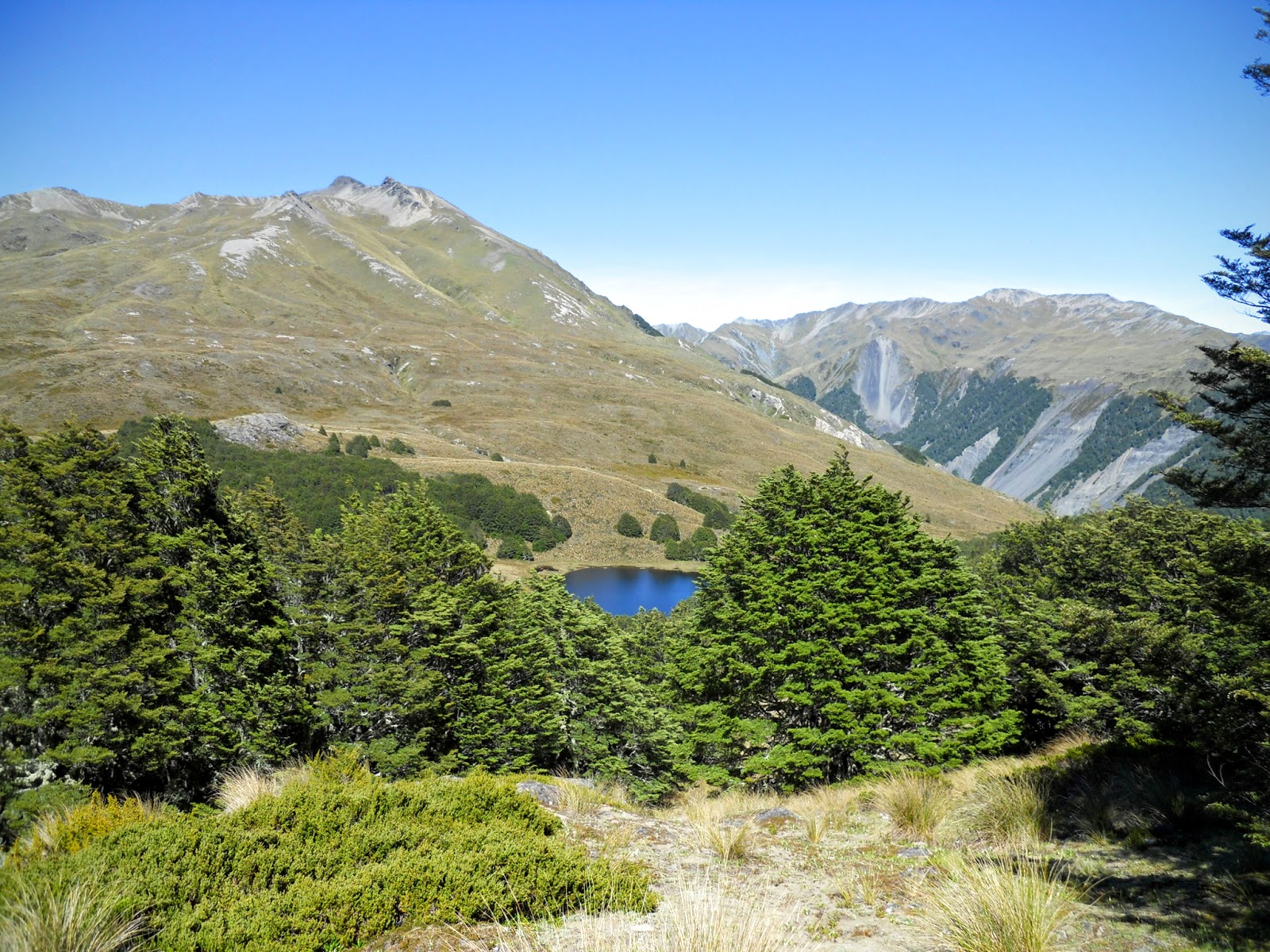
The tarns on Bealey Spur from the Lagoon Saddle Track


Mt Bruce, Craigieburn Forest Park from the Lagoon Saddle Track


Eventually you reach the saddle with its clear views down onto the large tarn that gives Lagoon Saddle its name. This is up towards Lagoon Saddle. From the Saddle, follow board-walked sections of the track down to the bush-line. Lagoon Saddle A-Frame Shelter (2 bunks) is a short distance lower down in the cover of the beech forest

The tarn on Lagoon Saddle from the Lagoon Saddle Track
Jon resting on the flank of Mt Bruce, Cass-Lagoon Saddle Track


First view of Lagoon Saddle A-Frame Hut, Harper Valley

Lagoon Saddle A-Frame Hut is a small 2-3 person hut near the outlet of the tarn on Lagoon Saddle. There are two bunks/mattresses with space for a third person on the floor. Fairly basic accommodation but perfectly adequate as a lunch or overnight stop.

Lagoon Saddle A frame Hut, Craigieburn Forest Park

Interior of Lagoon Saddle A Frame Hut

Please note the area around Lagoon Saddle A-Frame Hut is very swampy with few good camp-sites. You would be better to camp in the nearby forest as it is fairly open in nature. 

The swampy land surrounding Lagoon Saddle A Frame Hut
Alternately Lagoon Saddle Hut is located across the valley from the A Frame, cross in front of the waterfall and follow the short track.

Map: location of Lagoon Saddle Hut

Lagoon Saddle Hut, Craigeburn Forest Park

Interior of Lagoon Saddle Hut...Spartan but waterproof!
 It is basically a metal shed but has a couple of platforms for beds, but is waterproof and the river is not that far away as your water source. There is no heating and no insulation so it is really cold. It can probably hold 5-6 if people are willing to sleep on the concrete floor.

  Lagoon Saddle Hut to West Harper Hut: 5 km's: 2-3 hours

The track then descends from Lagoon Saddle to the Harper River. The next section down to West Harper Hut has numerous river crossings but these are straightforward in normal weather conditions, the track is well marked and easy to follow.

In the open forest just past Lagoon A Frame Hut


Map: Lagoon Saddle to West Harper Hut


A clearing in the Harper River Valley, Craigieburn Forest
Eventually you will arrive at West Harper Hut, a historic musterers hut.West Harper Hut, with its dirt floor and canvas bunks, provides historical interest and welcome shelter in poor weather. Otherwise it is best to push on to the Hamilton Hut or stay at one of the Lagoon Saddle Huts. 


West Harper Hut, Craigieburn Forest Park

West Harper Hut, Craigieburn Forest Park

As you can see the hut is very largely still in its original condition...it is very basic accommodation. BTW, those canvas bunks are the most devilish instrument of torture ever devised by one man to punish another. 

There is plenty of space around the hut to camp if that suits you better.


The rustic interior of West Harper Hut, Craigieburn Forest Park
I stopped at the hut for a break, it may be basic but at least it protects you from the murderous sand-flies you get in the area.

West Harper Hut to Hamilton Hut:

Beyond the West Harper Hut  the route is an all weather one sidling alongside the river for about 2 hours. The Harper River is crossed on a swing bridge 20 minutes from Hamilton Hut. There is also a awesome 3-wire bridge across Hamilton Creek about 5 minutes walk from Hamilton Hut.

Walking in the Harper River Valley

The Harper River close to the swing-bridge

Map: West Harper Hut to Hamilton Hut, Craigeburn Forest Park

The Harper River swing-bridge, crossing the Harper River
In between Harper River swing-bridge and the bridge over Hamilton Creek

Eventually you arrive at Hamilton Hut, or 'the Hamilton Hilton' as local trampers call it. It is in a nice location high above the river on a terrace. Hamilton Hut is possibly the largest hut you will visit on the Te Araroa, it only has 20 bunks but it has a lot of extra living space.

Hamilton Hut aka the Hamilton Hilton, Harper River Valley

There was a very handy wheel barrow at the hut which made it easy to hump firewood to the door, I wish more DOC huts had one.

Hamilton Hut, Craigieburn Forest Park
A well appointed DOC hut, Hamilton Hut has a mountain radio if you want to listen to the weather reports. There are two bunk rooms with a large communal living area...the wood burn works a real treat.

Interior of Hamilton Hut from Tramping.net.nz

Interior of Hamilton Hut from Tramping.net.nz

Interior of Hamilton Hut from Tramping.net.nz

To be continued:

Access: SOBO from Arthurs Pass via SH 73 road walk or hitch to start. NOBO from Hamilton Hut, via the Cass-Lagoon Saddle Track to SH 73 at Cora Lynn Station
Track Times: 15 km's or 6-7 hours Cora Lynn Station to Hamilton Hut
Hut Details: Bealey Hut: standard, 6 bunks, wood burner, water tank, toilet; Lagoon Saddle A Frame Hut: basic, 2-3 bunks, water from stream, toilet; Lagoon Saddle Hut: basic 5-6 spaces, water from stream; West Harper Hut: basic, 5 bunks (canvas), open fire, water from stream; Hamilton Hut: serviced, 20 bunks, wood burner, woodshed, water tank, toilets
Miscellaneous:High alpine conditions over winter, watch weather in region, rivers flood easily in heavy rain, some fall and rock fall hazards. Avalanche zone from May-November.