Tuesday 26 June 2018

SI Section: Harpers Pass: Windy Point to Hope-Kiwi Hut; Lake Sunmer Forest Park

On the Harpers Pass Track


I have done a couple of trips into Hope Kiwi Hut in Lake Sumner Forest Park, this is a part of the Harpers Pass crossing of the Southern Alps between Windy Point on SH 7 and Aickens on the Otira River.

Note this post has an amalgam of photos from different trips. 

The Boyle river swing-bridge, Hope-Kiwi track, Lake Sumner Forest Park

This is just day one of a longer 3-5 day trip, I am hoping to finish the rest of this section over the summer 2018/2019. I have had three attempts to do the whole Harpers Pass crossing all of them scuppered by bad weather and flooded rivers.

Windy Point to Hope Kiwi Hut: 6-7 hours approx. 17 km's

The Lake Sumner Forest Park starts at the fence line surrounding the Windy Point shelter, this is the pick up point for the bus running between Westport and Christchurch. If you have resupplied in Hanmer this is the best location to re enter the Te Araroa Trail.

The bus shelter at Windy Point, Lake Sumner Forest Park

 The shelter is very basic: three sided with no toilet or water so no god for camping. The track ascends the river terraces visible directly ahead and then sidles around the side of the Doubtful Range for the two-three hour walk to Hope Halfway Hut. 


The Hope Kiwi Track: first section from Windy Point to near Hope Halfway Hut


Start of the Hope Kiwi Track, Lake Sumner FP

DOC sign at the start of the Hope Kiwi Track, Lake Sumner FP

After walking 15 minutes up the gravel road you will see a turn off for the swing-bridge over the Boyle River, it is clearly marked so it is not difficult to navigate. You drop down to the crossing point and cross the river on the high swing-bridge suspended over the Boyle River Gorge.


Turn off to the Boyle River swing-bridge, the Hope Kiwi Track, Lake Sumner FP

Jon waking down to the Boyle River swing-bridge

Boyle River swing-bridge, the Hope Kiwi Track, Lake Sumner FP

On the far-side of the river you climb to the top of the old river terraces on a farm 4 W/D track, towards the top you cross through a strange little gate in the deer fencing, the only one of its kind I have ever seen in 20 years of tramping.


DOC park map of this end of Lake Sumner FP, Hope Kiwi Track

 Hope Kiwi Track, Lake Sumner FP, on the old farm track


The hatch in the deer fence on the Hope Kiwi Track, Lake Sumner FP

The Hope Kiwi Track, Lake Sumner FP continues along the right of the deer fence

The turn off to the Tui Track (which links with the Boyle River section of the TA) is about 500 meters up the track from the deer fence.

 Hey NOBO's, if you follow Tui Track it will eventually dump you out on SH 7 near the Boyle Outdoor Education Centre. Be aware that it crosses two un-bridged and dangerous rivers en route.


Turn off to Tui Track, the Hope Kiwi Track, Lake Sumner FP

Tui Track leading off to the Doubtful River, from the Hope Kiwi Track, Lake Sumner FP

To start with you cruise through some regenerating Manuka/Kanuka bush before hitting the beech forest about  1.5 kilometres along the Hope-Kiwi Track.


4 W/D track leading to edge of bush, the Hope Kiwi Track, Lake Sumner FP

Don't drink the water in this tarn as there are stock about so it will be contaminated...


An interesting tarn near the start of the Hope Kiwi Track, Lake Sumner FP

Track through the Manuka, the Hope Kiwi Track, Lake Sumner FP

Eventually you arrive at the beech forest after walking for 45 minutes, from here you are in forest for the rest of the way to Hope Halfway Hut some 5 odd kilometres away. The track is quite nice...not overly muddy, flat and usually well maintained it makes for swift walking.

Into the beech forest on the Hope Kiwi Track, Lake Sumner FP

Hope Kiwi Track, Lake Sumner FP, a wind fall tree from recent storms


The Hope Kiwi Track, Lake Sumner FP: an easy flat track


A mire or alpine swamp on the Hope Kiwi Track, Lake Sumner FP


Here is some pig sign I spotted along the track, wild pigs turn the earth looking for roots, grubs and other insects to eat. Lake Sumner has some of the best pig hunting areas in the whole of Canterbury. 


Pig rooting sign on the Hope Kiwi Track, Lake Sumner FP

About an hour up the Hope Valley you break out onto an open area so you can see up and down the valley. All the land on the far-side of the river is a high country sheep and cattle station.

Looking across the Hope River to the Glynn Wye range and a sheep farm

Looking up the Hope Valley from the Hope Kiwi Track, Lake Sumner FP

You cross a number of streams and rivers as you close in on Hope Halfway Hut, most are easy to cross. However, Boundary Stream close to Hope Halfway Hut can be a problem in heavy rain as it is prone to flooding.


One of several side streams you need to cross, the Hope Kiwi Track, Lake Sumner FP


Boundary Stream on the Hope Kiwi Track, Lake Sumner FP

After about three hours you finally arrive at Hope Halfway Hut, just past the mid way point to Hope Kiwi Hut. The hut is officially a shelter but it has had six bunks (plus mattresses) and a bench added to it by the NZDA so you can now sleep there. There is a toilet but no water tank so you have to fetch water from a nearby stream. 

This hut is not the Ritz so be aware if you are thinking of staying here, you will be roughing it a bit.

Hope Half Way Hut in its clearing, Lake Sumner FP

Close view of the small Hope Halfway Hut, Lake Sumner FP

Side view of Hope Halfway Hut, Lake Sumner FP

Past Hope Halfway Hut you have another seven kilometres to cover before you get to Hope Kiwi Hut. It is a mixture of forest and river flat travel, there is one short climb to access the swing-bridge over the Hope River but apart from that it is flat.


In the open forest beyond Hope Halfway Hut, Lake Sumner FP


Map: Hope Halfway Hut to Hope Kiwi Lodge, Lake Sumner FP


Looking down the Hope Valley from past Hope Half Way Hut


On the river flats mid reaches of the Hope River on the Hope Kiwi Track

View of the Hope River, the Hope Kiwi confluence is just visible in the distance

DOC sign, Hope Kiwi Lodge on the Hope-Kiwi Track, Lake Sumner FP

As you approach the Hope River swing-bridge you climb over a small wooded spur, then descend down to the river. This was really the only climb on this whole section of the Hope Kiwi Track. 

The Hope River passes through a gorge here, it is really beautiful with the deep Turquoise water, the swing-bridge and the forest.


Climbing up to the Hope River swing-bridge, Hope-Kiwi Track, Lake Sumner FP


Hope River Gorge, from the Hope River swing-bridge

Hope River swing-bridge from the Harpers Pass side of the river

Closer view of the Hope River swing-bridge
Once over the swing bridge it is about 30-40 minutes walk to Hope Kiwi Lodge through easy forest and grasslands. The Hope Kiwi Lodge is a real beauty: a Lockwood design so lots of exposed wood, nice living space and two bedrooms with 10 bunks apiece. 

It is really larger than the pre Te Araroa Trail traffic warranted, prior to 2010 only 10-12 parties a year went across Harpers Pass.  Now the hut is often filled to capacity over the main summer tramping season (December to March). 

There is a volunteer DOC hut warden here over the Summer.


First view of Hope Kiwi Lodge from the Hope-Kiwi Track, Lake Sumner FP

Hope Kiwi Lodge, Hope-Kiwi Track, Lake Sumner FP

Here are a couple of photos of the inside of Hope Kiwi Hut, a strange thing...this hut has linoleum on the floor the only DOC hut I have ever seen with this feature. This would be a great hut to stop for a zero day.


Hope-Kiwi Lodge: photo of one of two bunk rooms, from Tramping.net.nz

Hope-Kiwi Lodge: The kitchen with snazzy lino floor...from Tramping.net.nz

From here SOBO's would set out for Hurunui Hut near Lake Sumner or possibly Hurunui No.3 if you walk fast and leave early. NOBO's would follow my path back to Windy Point and from there to Boyle Outdoor Education Centre or Hanmer to resupply.


To be continued:

Access: SOBO from Arthurs Pass via Harpers Pass Track. NOBO from Windy Point on SH7, on the Hope Kiwi Track
Track Times: 17 km's or 6-7 hours Windy Point to Hope Kiwi Lodge
Hut Details: Hope Halfway Hut: basic, 6 bunks, toilet, water from stream; Hope Kiwi Lodge: serviced, 20 bunks, wood burner, woodshed, water tank, toilets, Hut Warden December to March
Miscellaneous:High alpine conditions over winter, watch weather in region, rivers flood easily in heavy rain.

Sunday 10 June 2018

SI Section: Cora Lynn Station to Hamilton Hut: Arthurs Pass NP-Craigieburn Forest: 2012 + 2015

On the Te Araroa in Cragieburn Forest Park


Ive done two trips along this section of the Te Araroa Trail once in 2012 and another in 2015. The section from Hamilton Hut to SH73 is part of the popular Cass-Lagoon Saddle Track which I tramped back in 2012. I also did a day walk into Lagoon Saddle Hut in 2015, this post is a combination of photos from those two trips.


Track to the beginning of the Lagoon Saddle Track, Cora Lynn Station
Access to this section of the trail starts just off State Highway 73, at the turn off to the Cora Lynn Station. This is approximately 3-4 kilometres past the Bealey Hotel.

SH73 to Lagoon Saddle Hut: 6 km's, 3 hours

The track climbs a short distance from the car-park to Bealey Hut, a basic 6 bunk hut off on a short side trail to the right.There is space for several tents in front of the hut, the hut has toilets and a water tank you may use.

Map: Cora Lynn Station Road to Lagoon Saddle

The track starts just to the right of Bealey Hut if you are walking in a South bound direction.


Track map at the entrance to the Lagoon Saddle Track, Craigieburn Forest

Bealey Hut is an old NZFS70 six bunk hut built in the 1960's. It is in remarkably good condition considering how close to the road it is, it is a bit rustic inside but it is dry, relatively warm and well placed to start the 6-7 hour walk to Hamilton Hut.


Bealey Hut, Craigieburn Forest Park

Interior of Bealey Hut, Craigieburn Forest Park

Interior of Bealey Hut, Craigieburn Forest Park
This track runs through Craigieburn Forest Park, there is a sign about 100 meters up the track on the boundary of the park.


Sign denotes beginning of Craigeburn Forest Park, Lagoon Saddle Track

Beyond the hut the track continues to climb through beech and exotic forest. It then traverses the broad north face of Mt Bruce, initially through forest but then through open tussock country.

Start of the climb into the forest, Lagoon Saddle Track


Jon climb along the Lagoon Saddle Track


Lagoon Saddle Track, open beech forest further up Mt Bruce

About an hour along the track the vegetation changes to exotic forest, this was a trial erosion prevention planting by the old New Zealand Forest Service. These are mostly Pinus Radiata trees planted in the late 1980's.


Lagoon Saddle Track, change to exotic pine trees

There are some nice views of the large Waimakiriri River Valley once you hit the edge of the forest.


Waimakiriri River Valley looking to the head of the river from the Lagoon Saddle Track


Waimakiriri River Valley looking East from the Lagoon Saddle Track

Once out of the forest you walk through tussock for about 45 minutes before gaining the crest of Lagoon Saddle. The track condition is generally good with some swampy spots along its length.

Lagoon Saddle Track, out of the forest and into the tussock


Native mountain daisy alongside the Lagoon Saddle Track


From the flank of Mt Bruce there are some spectacular views down onto Bealey Spur and the Waimakiriri River Valley further to the West.

The tarns on Bealey Spur from the Lagoon Saddle Track


Mt Bruce, Craigieburn Forest Park from the Lagoon Saddle Track


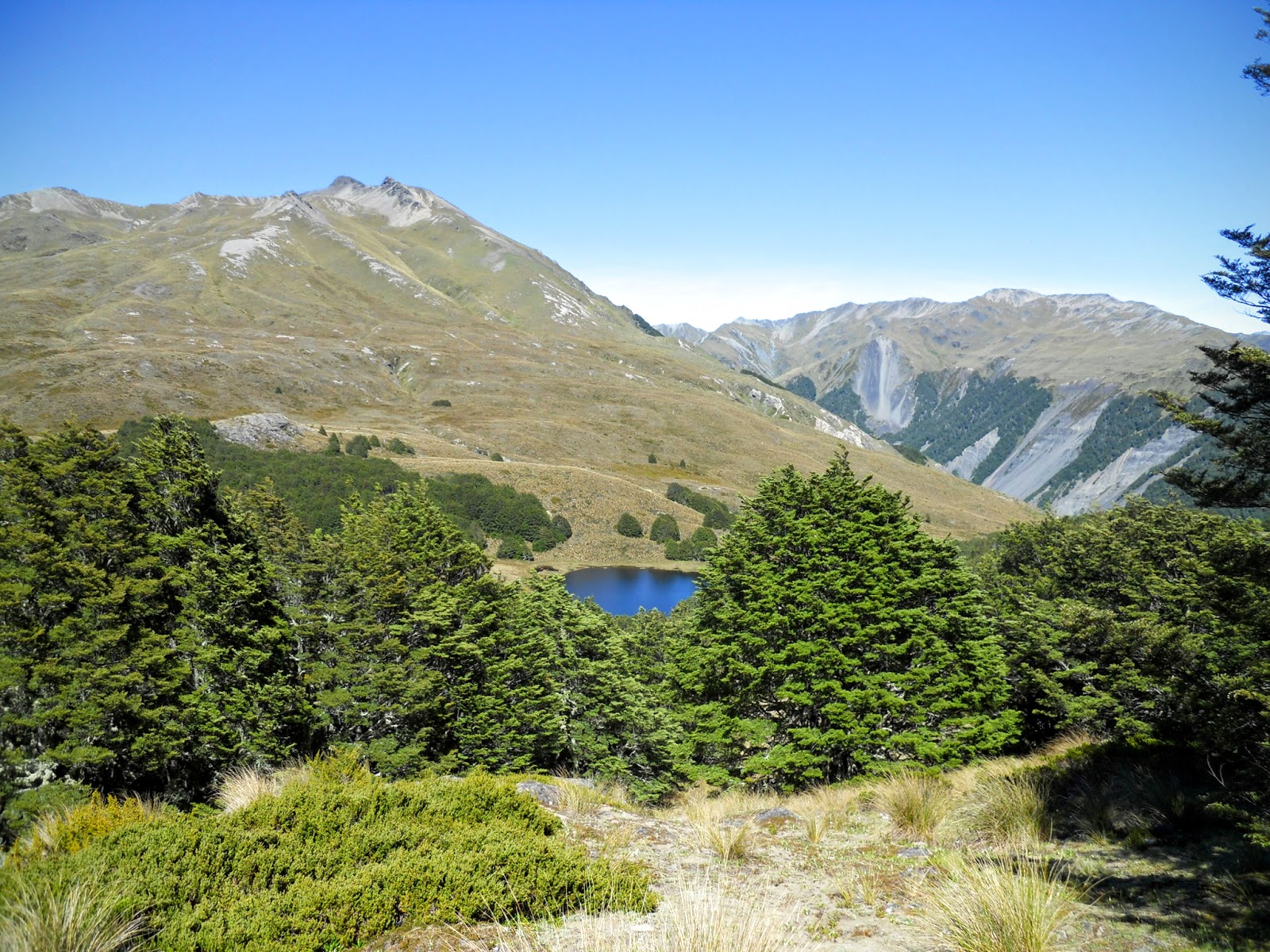
Eventually you reach the saddle with its clear views down onto the large tarn that gives Lagoon Saddle its name. This is up towards Lagoon Saddle. From the Saddle, follow board-walked sections of the track down to the bush-line. Lagoon Saddle A-Frame Shelter (2 bunks) is a short distance lower down in the cover of the beech forest

The tarn on Lagoon Saddle from the Lagoon Saddle Track
Jon resting on the flank of Mt Bruce, Cass-Lagoon Saddle Track


First view of Lagoon Saddle A-Frame Hut, Harper Valley

Lagoon Saddle A-Frame Hut is a small 2-3 person hut near the outlet of the tarn on Lagoon Saddle. There are two bunks/mattresses with space for a third person on the floor. Fairly basic accommodation but perfectly adequate as a lunch or overnight stop.

Lagoon Saddle A frame Hut, Craigieburn Forest Park

Interior of Lagoon Saddle A Frame Hut

Please note the area around Lagoon Saddle A-Frame Hut is very swampy with few good camp-sites. You would be better to camp in the nearby forest as it is fairly open in nature. 

The swampy land surrounding Lagoon Saddle A Frame Hut
Alternately Lagoon Saddle Hut is located across the valley from the A Frame, cross in front of the waterfall and follow the short track.

Map: location of Lagoon Saddle Hut

Lagoon Saddle Hut, Craigeburn Forest Park

Interior of Lagoon Saddle Hut...Spartan but waterproof!
 It is basically a metal shed but has a couple of platforms for beds, but is waterproof and the river is not that far away as your water source. There is no heating and no insulation so it is really cold. It can probably hold 5-6 if people are willing to sleep on the concrete floor.

  Lagoon Saddle Hut to West Harper Hut: 5 km's: 2-3 hours

The track then descends from Lagoon Saddle to the Harper River. The next section down to West Harper Hut has numerous river crossings but these are straightforward in normal weather conditions, the track is well marked and easy to follow.

In the open forest just past Lagoon A Frame Hut


Map: Lagoon Saddle to West Harper Hut


A clearing in the Harper River Valley, Craigieburn Forest
Eventually you will arrive at West Harper Hut, a historic musterers hut.West Harper Hut, with its dirt floor and canvas bunks, provides historical interest and welcome shelter in poor weather. Otherwise it is best to push on to the Hamilton Hut or stay at one of the Lagoon Saddle Huts. 


West Harper Hut, Craigieburn Forest Park

West Harper Hut, Craigieburn Forest Park

As you can see the hut is very largely still in its original condition...it is very basic accommodation. BTW, those canvas bunks are the most devilish instrument of torture ever devised by one man to punish another. 

There is plenty of space around the hut to camp if that suits you better.


The rustic interior of West Harper Hut, Craigieburn Forest Park
I stopped at the hut for a break, it may be basic but at least it protects you from the murderous sand-flies you get in the area.

West Harper Hut to Hamilton Hut:

Beyond the West Harper Hut  the route is an all weather one sidling alongside the river for about 2 hours. The Harper River is crossed on a swing bridge 20 minutes from Hamilton Hut. There is also a awesome 3-wire bridge across Hamilton Creek about 5 minutes walk from Hamilton Hut.

Walking in the Harper River Valley

The Harper River close to the swing-bridge

Map: West Harper Hut to Hamilton Hut, Craigeburn Forest Park

The Harper River swing-bridge, crossing the Harper River
In between Harper River swing-bridge and the bridge over Hamilton Creek

Eventually you arrive at Hamilton Hut, or 'the Hamilton Hilton' as local trampers call it. It is in a nice location high above the river on a terrace. Hamilton Hut is possibly the largest hut you will visit on the Te Araroa, it only has 20 bunks but it has a lot of extra living space.

Hamilton Hut aka the Hamilton Hilton, Harper River Valley

There was a very handy wheel barrow at the hut which made it easy to hump firewood to the door, I wish more DOC huts had one.

Hamilton Hut, Craigieburn Forest Park
A well appointed DOC hut, Hamilton Hut has a mountain radio if you want to listen to the weather reports. There are two bunk rooms with a large communal living area...the wood burn works a real treat.

Interior of Hamilton Hut from Tramping.net.nz

Interior of Hamilton Hut from Tramping.net.nz

Interior of Hamilton Hut from Tramping.net.nz

To be continued:

Access: SOBO from Arthurs Pass via SH 73 road walk or hitch to start. NOBO from Hamilton Hut, via the Cass-Lagoon Saddle Track to SH 73 at Cora Lynn Station
Track Times: 15 km's or 6-7 hours Cora Lynn Station to Hamilton Hut
Hut Details: Bealey Hut: standard, 6 bunks, wood burner, water tank, toilet; Lagoon Saddle A Frame Hut: basic, 2-3 bunks, water from stream, toilet; Lagoon Saddle Hut: basic 5-6 spaces, water from stream; West Harper Hut: basic, 5 bunks (canvas), open fire, water from stream; Hamilton Hut: serviced, 20 bunks, wood burner, woodshed, water tank, toilets
Miscellaneous:High alpine conditions over winter, watch weather in region, rivers flood easily in heavy rain, some fall and rock fall hazards. Avalanche zone from May-November.